Friday, December 08, 2006

Segue City One

Segue City One is what I have seen as the first of many mega developments which work as a unit to increase efficiency and effectiveness in global trade. The city discussed here is a result of research done earlier this semester in Mega Blog posts and the Mapimation project.

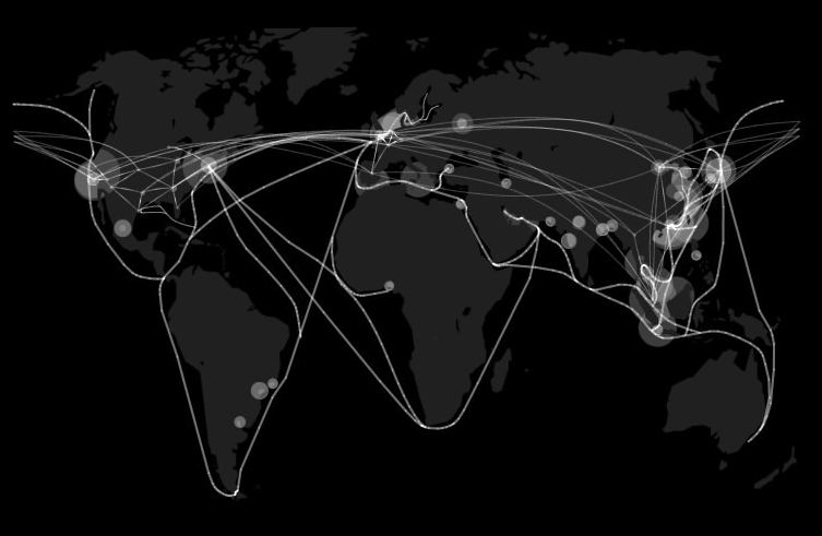
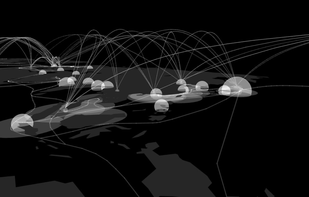
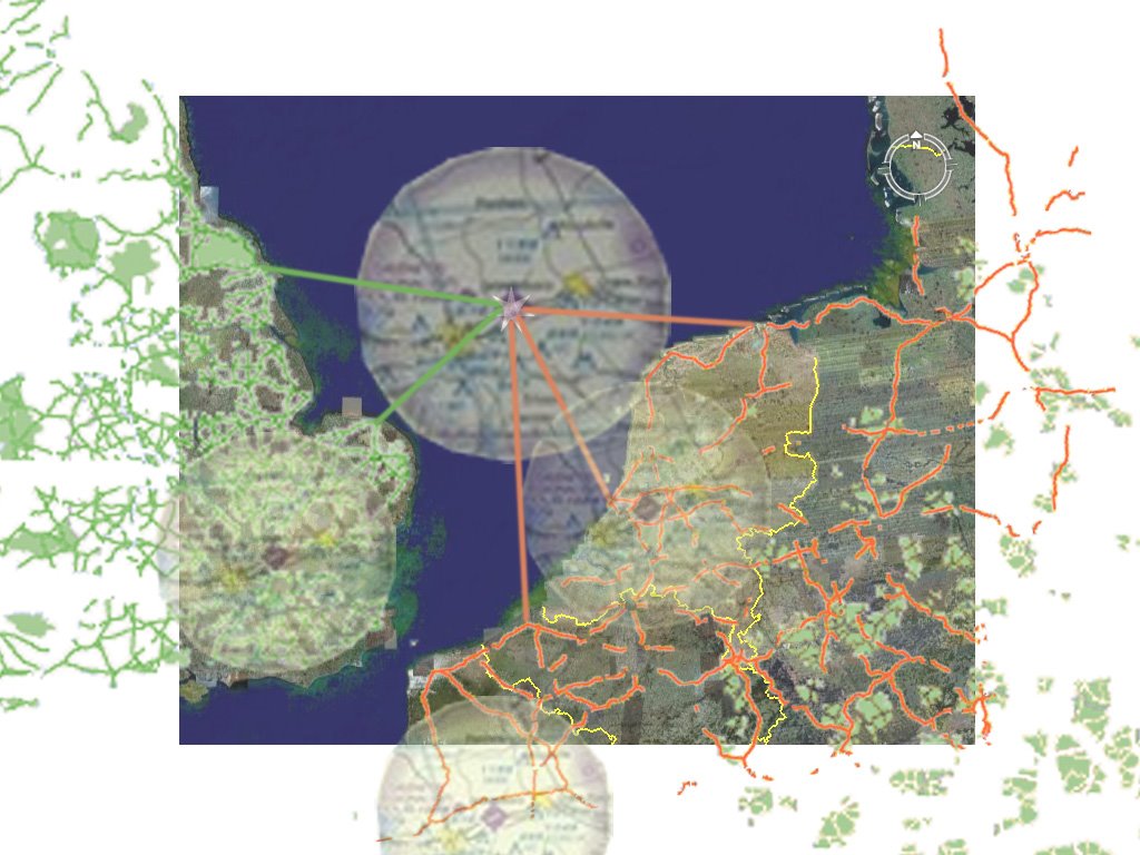
The Mapimation project was the precursor to Segue City One; here I explored global transportation networks. The map overlaps the world’s largest cities, ports, airports, and rail and road networks to find areas of intense overlap of the world’s largest transportation networks. These areas are crucial as distribution hubs in the global economy. However, the cities that act as major player in global trade, unsightly ports, noisy airports, and disruptive road and rail networks lower the living quality of these cities. Segue cities are meant to be new developments at the crossing of major transportation systems. The segue city acts as a mega hub for all passenger and cargo traffic entering the region it serves. For example, here Segue City One serves most of Western Europe as a gate to the entire continent. In this way, undesirable characteristics of transportation networks are retreated to the segue city leaving behind prime real estate on the mainland and leaving the exchange of goods and passenger layovers to one specially designed location.

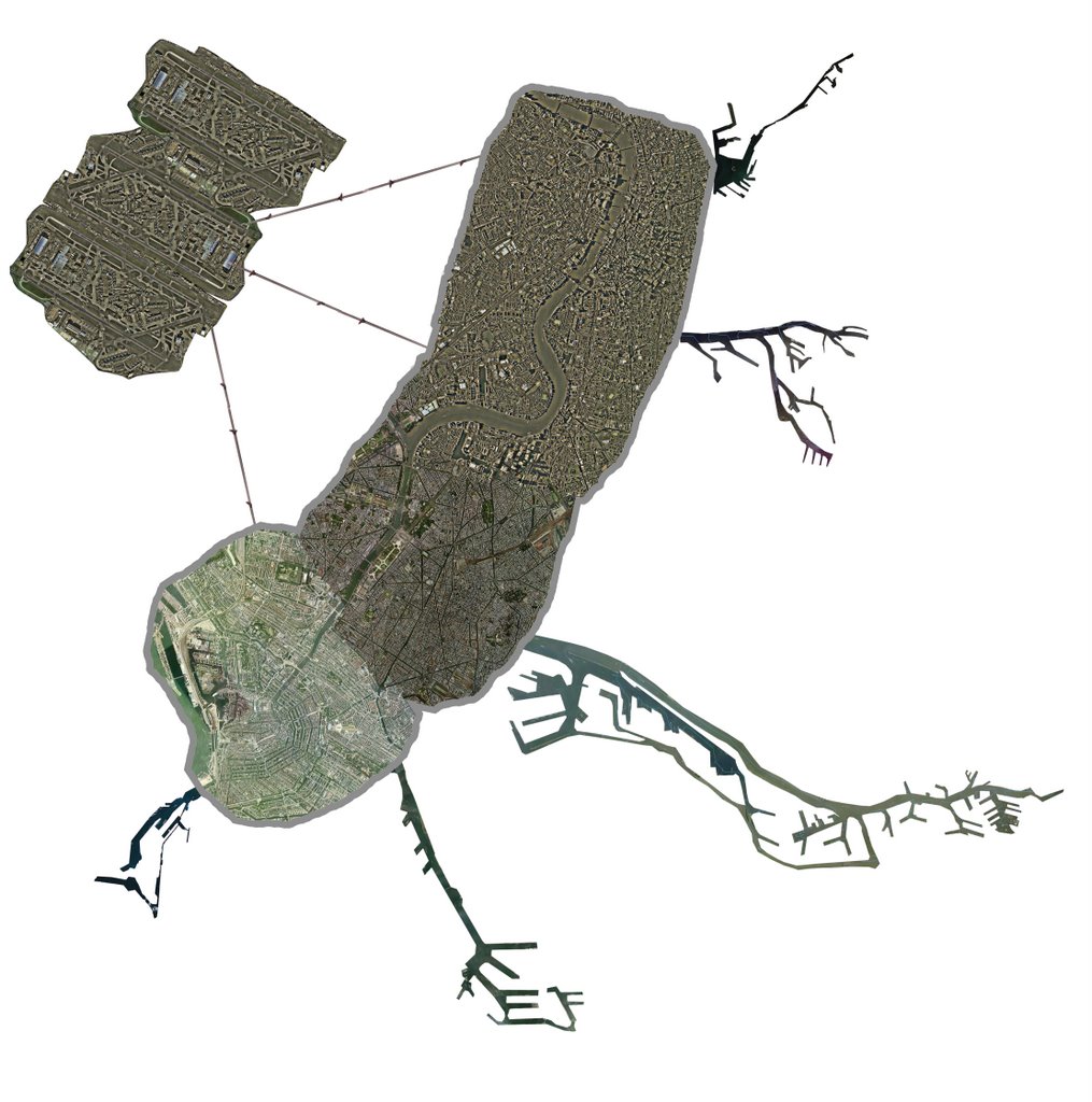
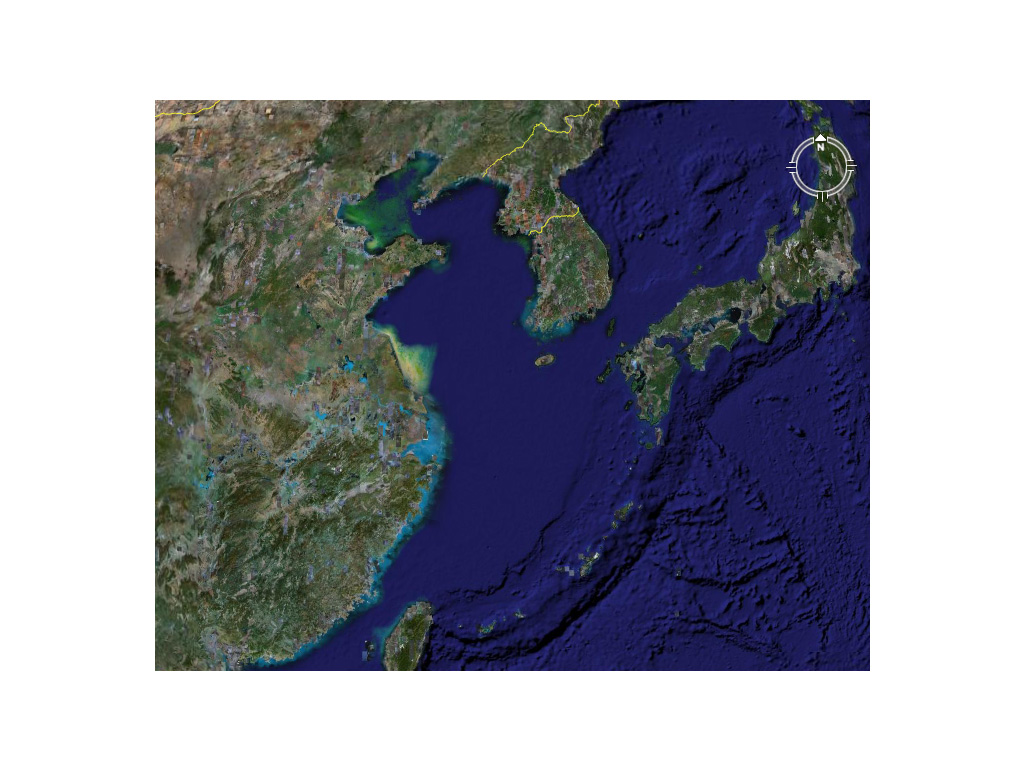
Segue City One is located in the North Sea, it lies central to some of the main cities it supplies such as London, Amsterdam, Rotterdam, Copenhagen, Hamburg, Paris and others. The city is constructed as a collage of the areas it serves. Five main elements create Segues City One, those being: 1) the city itself, 2) the green spaces, 3) the airports 4) the seaports and 5) the rail and road circulation network.

We will begin with the city. The city is a composition constructed of large samples of the largest cities of the region served—London, Paris, Amsterdam, Berlin, Hamburg, and Frankfurt. These are some of the most influential cities of the region. The sections of the city are oriented in a way that corresponds with the actual cities they have been modeled after. While Segue City One’s purpose is to house rather industrial processes, the city is created in a way that still offers a comfortable living environment.

This brings us to the green spaces. A ring of green grounds foreseen to have a park like atmosphere surrounds the perimeter of the city. All of the industrial operations, the ports and airports are located outside of this “green ring” and are thus screened from the city itself. A bay has been left in the center of the city to give occupants a comfortable waterfront to enjoy seeing as the border with the ocean on the perimeter of the city is surrounded by the transportation networks.

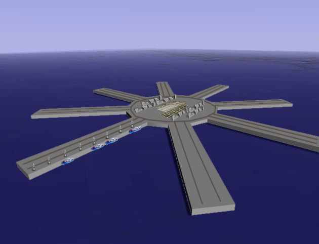
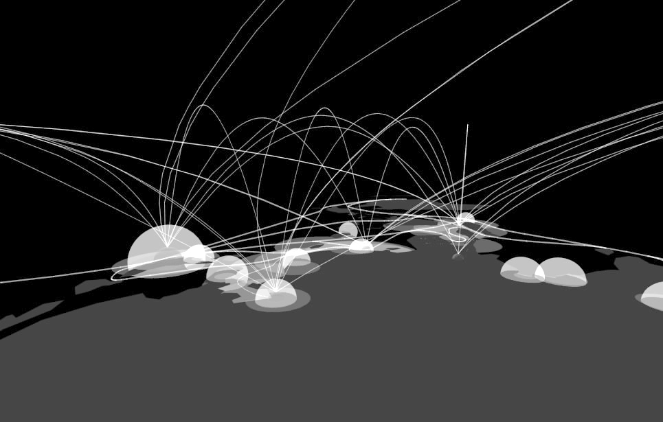
The transportation network consists of a central loop from which arteries branch down the length of each port. These arteries support both rail lines and roads which carry goods to and from ships in the ports. The network is then connected to the mainland of England and Holland via Chunnel system thus plugging goods directly into the rail and road infrastructures of Western Europe. The central loop is located under the city while the arteries surface onto each port dock.

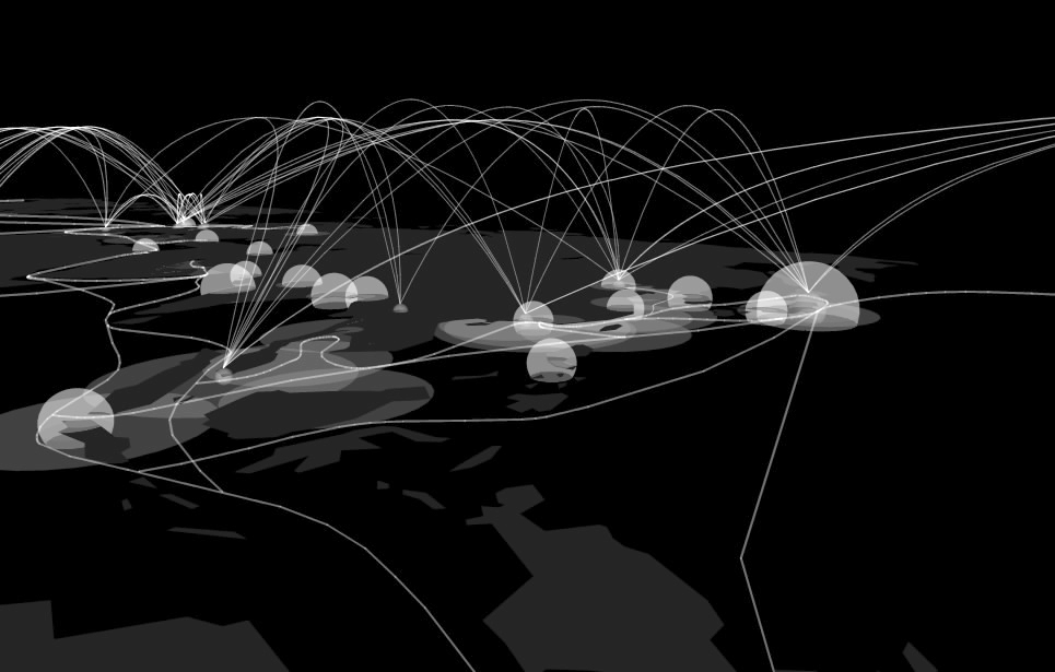
The ports are a collection of Western Europe’s largest ports; that is the ports in Rotterdam, Antwerp, Hamburg, Copenhagen and Le Havre. They have been designed as a negative of the areas making up these ports. That is to say what are channels and canals in the existing ports have become the docks in the Segue City One ports. The hope is that a similar organization of operations can continue since the structure of each port is essentially the same as its inspired port. Like the city fabrics, the ports are oriented in directions pointing to their original locations.

And finally the airports, I have selected three of Europe’s existing airports, those in London, Amsterdam and Frankfurt. The load that these airports carry today are equivalent to what I have calculated would be needed to support all intercontinental cargo and passengers entering and leaving Western Europe. Like the ports, the have been located outside the “green ring.”

In essence, the Segue City is a collage of the largest urban spaces and transportation networks of Western Europe designed to take the load of the exchange of goods and international trade off of the mainland leaving valuable real estate and more comfortable living conditions.

The following link will lead you to an earlier study massing model which has a similar effect to the final project: Segue Interactive Model

Below is my PowerPoint presentation, to be replace by images later.

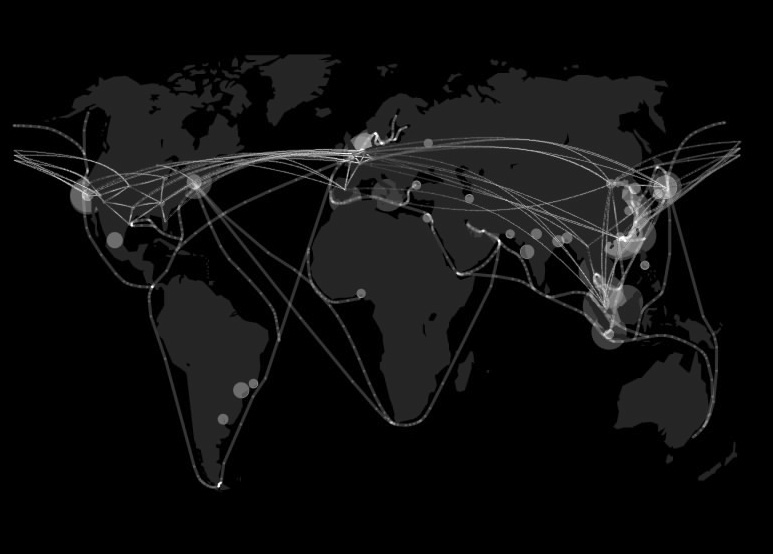
Global Transportation Networks

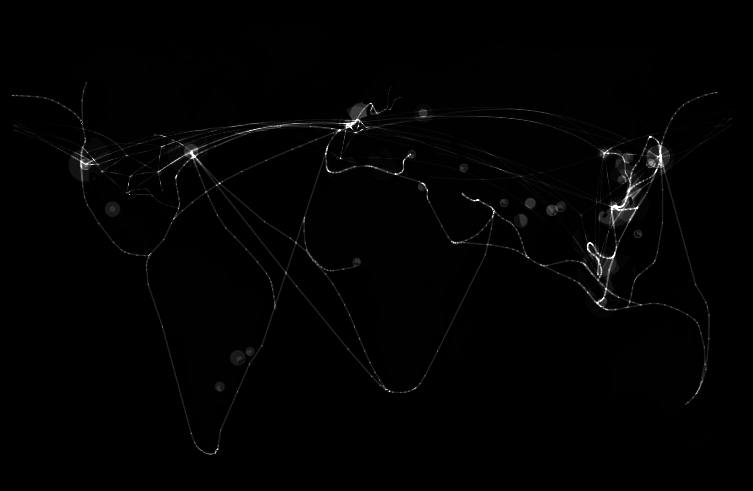
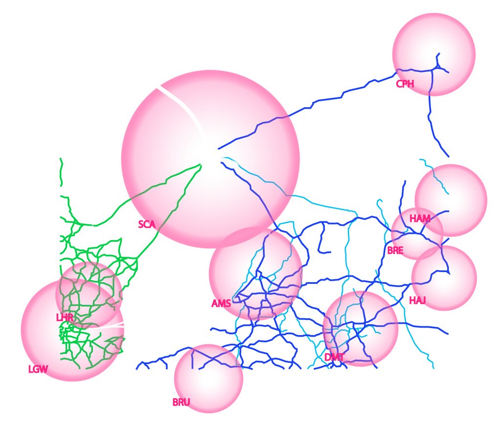
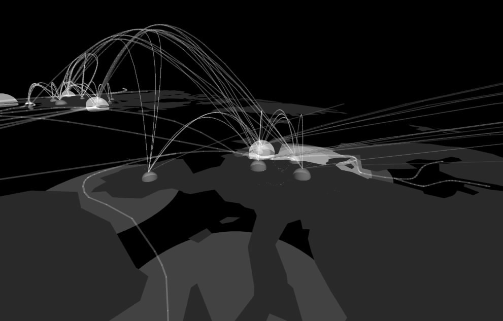
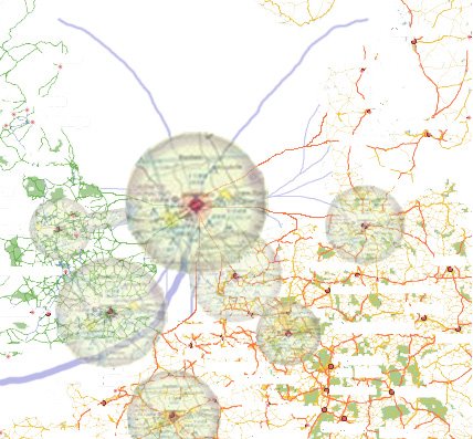
European Network Collisions


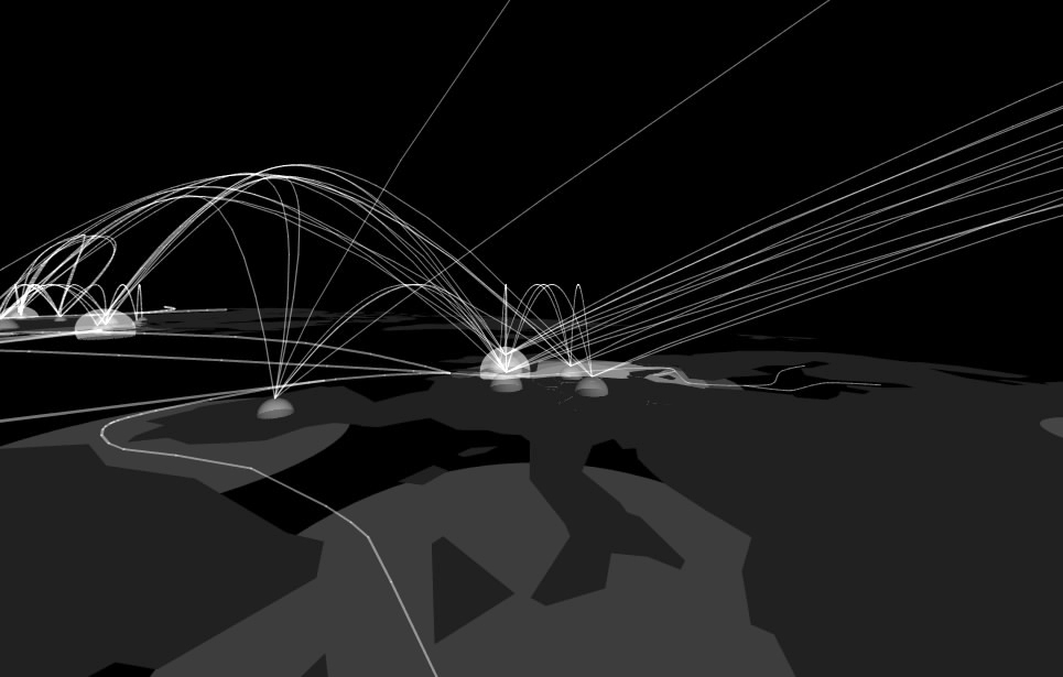
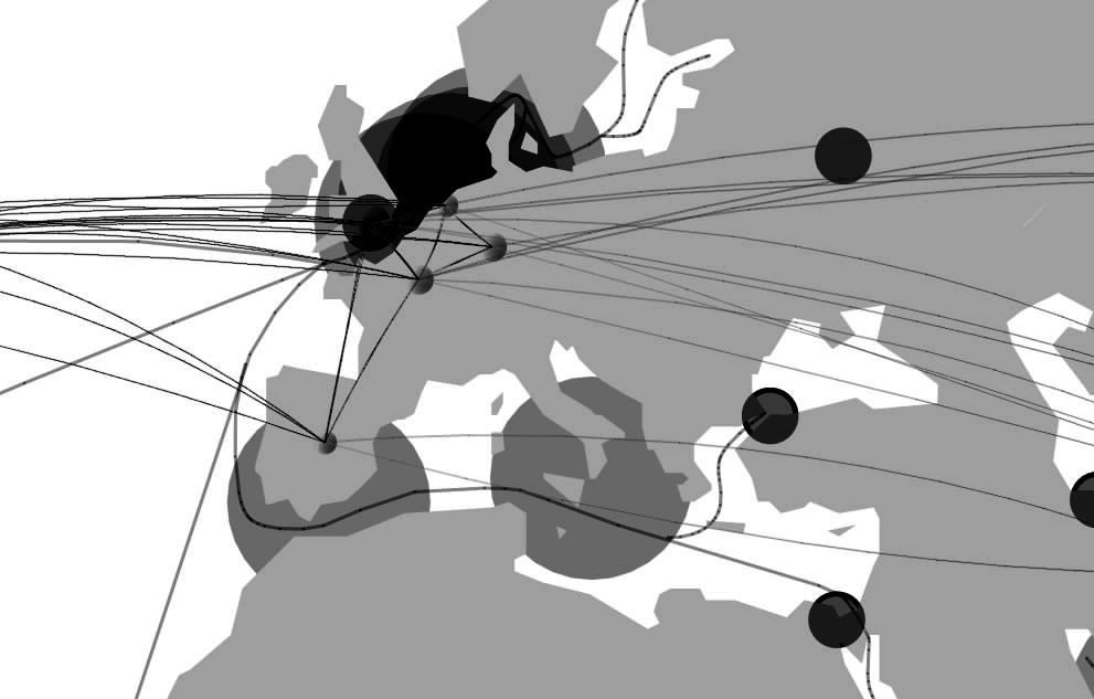
New European Road Map
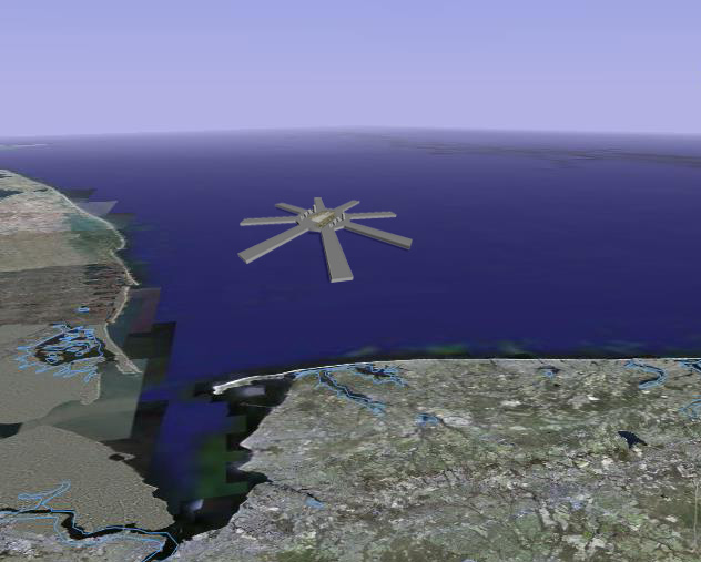

North Sea Location

Veiw from Space


Component Collage


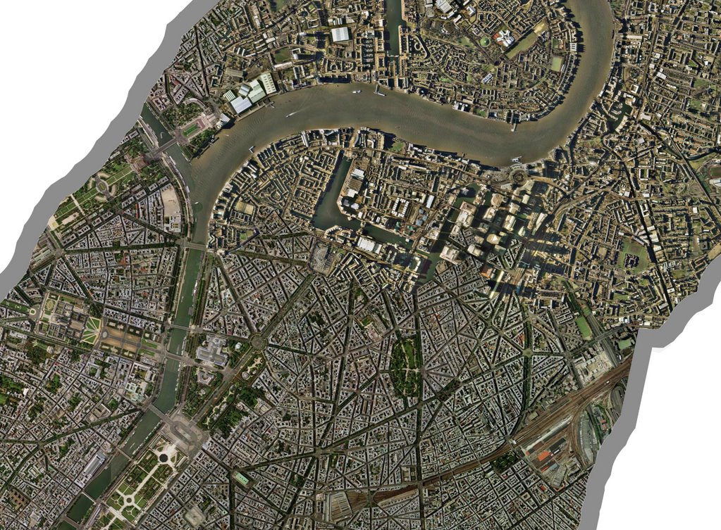
London/Paris Collision

City Block Figure Ground

"Green Ring"


Airports


Seaports


FormZ Model

View over Segue City One Bay


View Down Rotterdam Port

View Along Inner Bay


Friday, December 01, 2006

12.01.06

The past few days have been dedicated to experimentation with FormZ, SketchUp and Google Earth. Here are some files that begin to show what I have learned: Trial Model 1 and Trial Model 2. I am now in the process of building the final, more detailed FormZ model of which a toned down version will be place into Google earth.

Wednesday, November 29, 2006

11.29.06

The following two images are the most recent of my Photoshop collage efforts. The top image incorporates the cities of London, Paris and Amsterdam; the ports of Copenhagen, Hamburg, Bremen, Rotterdam, Antwerp and Le Havre; and an airport three times the size of London Heathrow International. The second image is a close up view of the collision of two of the cities, London is on top and Paris on bottom. I also have a rough SketchUp massing model in Google Earth here.


Monday, November 20, 2006

11.20.06 Proposal

After some early experimentation, I have chosen to further develop a Segues City designed to serve the European continent. My mapping has shown the North Sea as an area of highly concentrated global traffic and a seemingly effective site for the location of a Segue City. This proposal began with a study of the major ports in Northern Europe including the ports in Le Havre, Antwerp, Rotterdam, Bremen, Hamburg, and Copenhagen. Using Google Earth maps, I found the area which each of these ports covered. The inverse of the land covered (the water ways occupied by the ports that is) was then used to create the port branches stretching from the center of my proposed Segue City. The idea is that each port in the Segue City could continue to function in the same organization as it currently does onshore.

The central island contains the actual city and the mega airport. The airport has been designed to accompany the loads of all of the inter-continental flights entering the major airports of the European Continent, both passenger and cargo. The airport needed to support this load is the equivalent of 3 Hartsville Atlanta International Airports (which has been modeled as such). The city of the island has been modeled after Manhattan in New York; it has been foreseen with a similar population density and covers roughly 18 square miles allowing 1.5 million people to inhabit the island. This figure is a response to the number of employees needed to operate all of the functions of the Segue City including families of the employees.

The second major function of the center island is the hub of both the rail and road networks in the city. Underground, an interstate loop and a rail loop allow the exchange of goods and people from one area if the city to another, but more importantly, the hubs are a means of transportation for goods and people onto the mainland of Europe. Chunnel systems will allow trains and trucks to transport goods and people directly to their destinations onshore. This relieves the pressure and confusion of the transportation of goods from ships to trains/trucks/planes on the mainland freeing up valuable real estate for other uses. Under the surface of the central island, the interstate loop and the rail loop are stacked on top of one another. Vertical transportation shafts will move goods with a system of elevators from the airport to trucks or trains or vice versa.

Several images below describe the process and proposal I have created thus far. The first two images go back to my mapimation project showing how the site for the European Segue City was chosen. Then a series of collages and perspectives give an idea of scale and the city in its context. Finally, the video gives a rough idea of the form of the Segues City and the different transportation networks that make the city a center for exchange. The model is a simple combination of extrusions and sweeps to give a reference of scale and form. The animation shows how the separate systems of transportation are interlocked with one another.


Monday, November 13, 2006

Image Updates for the Segue Cities

Some photoshop collages to follow up last week's sketches:


Friday, November 10, 2006

Segue City Program Proposal

After my conclusions from the mapping project, I have proposed four sites where I feel the creation of an offshore segue city would benefit the exchange of goods and movement of passengers throughout the globe. These sites are: Los Angeles, New York, the North Sea and the East China/Yellow Sea. I find the site in the North Sea especially interesting and plan to focus on this site especially for the purposes of this project.

Program of the Segue City—The Segue Cities will be transportation hubs for all major transportation networks supplying a fairly large area, in this case, most of north western and north Eastern Europe. The Segue City will consist of a central island, envisioned now to be and artificial island constructed in a similar fashion to the Kansai Airport (see earlier post). The central hub island would serve as a gateway airport to the larger served region, it would provide living areas for workers and their families in the Segue City and it would provide a ring of transportation connecting the spokes of the City described next. Below the surface of the central island, a rail network will gather, distribute and transport goods to and from the mainland. The second major component of the City will be the spokes that radiate from the central hub. These arms will be massive docking piers for all ships that would generally crowd the ports of the surrounding mainland. Goods will pass from the ship directly to the rail and interstate networks of the European continent. The arms radiating from the central hub are foreseen as floating island units. As demand for shipping increases, more units can be attached to the hub. I have researched a material called pykrete to perhaps serve as the main construction of the shipping islands. Pykrete is a material invented during WWII created with a simple mixture of wood pulp and sea water. In WWII, the Royal Navy suggested building a super aircraft carrier, the Habbakuk of pykrete which was discovered to have similar structural properties to concrete while floating like an iceberg. This link to the Habbakuk project further discusses the material.

Below are some early sketches of how the program of the Segue Cities may function:

Sunday, November 05, 2006

Mega Transportation Networks

The final phase of this mapping project goes beyond mapping only major air routes. This map super-imposes the world's four main modes of transportation used to physically connect every corner of the globe. The mapping explores the world’s largest air, shipping, rail and roadway networks. The map is done as such that each layer of information is displayed on the map as a partial transparency, thus the areas of the map which show the whitest moments represent the areas of the globe in which there are the highest concentration of intersections between the world’s largest transportation networks. These are the areas of the globe are the areas which move most of the world’s people and goods around the world. These are very important areas for the global economy and have a large impact on most of the world; they represent some of the wealthiest areas of the world and are also among the most populated places on the globe.

Below is a plan view of a map of the earth. The world’s mega cities (that is cities containing more than 10 million people) are plotted along with the world’s largest ports, airports, rail networks, interstate infrastructures and the most commonly traveled air routes and shipping lanes. The shipping lanes and air routes are mapped as lines of connections, the mega cities and airports are mapped as domes with radii in correspondence to global size, and the ports, interstate infrastructures and rail lines are mapped as flat circles centered on the mega cities they are tied to, the radii of these forms also have been derived from the global scale of these networks.


image 1


image 2

Shown above is the identical map of the globe seen before but the levels of the image have been altered to create a clearer understanding of the most critical areas of the overlapping of transportation networks. Four focus areas immediately become obvious, the eastern coast line of Asia between China and Japan especially, Northern Europe, the US northeast (centered on New York) and the US west coast (centered on Los Angeles). Following are several perspectives of the map including a front elevation view showing an interesting pattern across the globe, a perspective view of the Asian east coast from the Pacific Ocean and a second image taken over Russia and a perspective of Northern Europe taken form the northern part of the African continent, in that order.


image 3


image 4


image 5


image 6

The next map below describes the areas most affected by the largest transportation networks and which areas of the globe are less accessible than others. Following are two more maps, the first of which shows the population of the areas most affected by my mapping of transportation and the second which highlights GNP per capita (darker countries have higher GNP) in the areas of my mapping versus other areas of the globe. And finally, the last two images describe one of the most interesting sites on the globe, the North Sea. The Google Earth map (image 10) locates the road map that follows it. The last map is a transportation map, it disregards all information except that discribing transportation networks. The last map collage explores what the North Sea in northern Europe might look like if a "Segue City" island transportation hub (discussed below) were built to serve the European continent. In this map, the red, yellow and green lines represent major highways and interstates in northern Europe and England, the circles represent air space superiority for the largest airports in the area and the gray lines are shipping routes too and from the city. These maps are, however, only speculation of what could be if a mega "Segue City" was built in the North Sea.


image 7


image 8


image 9


image 10


image 11

Our lives today are based on a global economy and as the population of the world continues to grow, a global economy will be increasingly important for our living standards and perhaps for developing the situation of other areas that seem left out of the global economy at this time. I believe the that it will be increasingly important for the areas highlighted by this mapping to work as efficient and effective segues of goods and people and as the main distribution hubs of the world. In many of these areas, problems of space and ugly industrialization are major concerns as they will continue to be. An interesting study titled “What if Denmark was the Port to the New Europe?” describes these issues in Denmark and suggests a solution involving the construction of a new “super port” as a man-made island replacing the other ports which now crowd the Danish coastline. The study predicts great profit for the Danes and a higher quality of life due to the prime real estate which would be yielded if all of the ports were moved offshore. Similar situations are faced in all of the areas highlighted by the mapping and so the thought arises, what would happen if mega offshore “Segue Cities” were created to move the unsightly and ever growing transportation network hubs to a central location offshore? Just as airline hubs were formed to make airline travel more efficient, can this concept not be applied to all forms of transportation of both people and goods on a global scale to make international trade more efficient as a whole? For the next part of the project, I plan to explore the creation of “Segue Cities” which could operate in the strategic locations pointed out to create a new and more efficient means of global travel and transportation.

Thursday, November 02, 2006

Mappimation Progress

Here are some of the latest images of my FormZ mapping. the lines shown represent the main sea lanes and air routes connecting the "mega" ports and airports of the world. The ports are marked by flat circular areas corresponding to the size of the ports. Airports are marked by circular domes, size also corresponding to the size of the airport. And finally, all of the mega cities of the world are also marked with white spheres. The layering of this information reveals areas in the of intense white which are areas that are extremely developed as far as their global modes of transportation and ties to the rest of the world. These are areas that could be considered for the construction of Segue Cities. Still to come on the map is the plotting of major railroads and interstates around the globe (hope). Any suggestions?


Wednesday, November 01, 2006

Segue Cities Update

Some brainstorming for collage maps and proposals:

Monday, October 30, 2006

Segue Cities


After last week's review I have refocused my mapping to incorporate more than just the plotting of air traffic data. I have chosen to attempt mapping all of the major networks of transportation for people and goods including major air routes, shipping routes, interstate networks, and railway networks. These systems will be mapped over a plotting of the world's mega cities (that is any city with more that 10 million inhabitants); the idea is that when all of these layers of information are superimposed over one another, the map will reveal the most important "Segue Cities" of the world, that is to say, the cities which most control the movement of people and goods around the globe and in many ways, control a large factor of the global economy and the conditions many people around the world face.

I hope that these Segue Cities can become sites for a new system of global interaction. I suspect that many of these cities will encounter similar problems of population growth, unsightly conditions around the port areas, and a general confusion and inefficiency of distribution of people and goods. I plan to analyze the largest Segue Cities an pose a plan for the construction of an off coast island which could perhaps serve an of shore port/airport for a more efficient distribution of cargo and passenger traffic.

One very interesting corner is the North Sea. London and Paris are two mega cities which depend on a large import export business; the London, Paris, and Amsterdam airports are among the worlds largest, four of the world's largest ports are located here and finally, all of the countries in this general area contain strong rail and interstate networks. As the population continues to grow and more pressures are felt of the expansion of airports and ports what could a solution be to make the transport of goods and passengers in and out of the area more efficient. Inspired by an earlier case study on Kansai International Airport in Osaka, I began to wonder if it would be possible to build an island in the North Sea which would serve as a major airport and seaport to receive and send northern Europe's goods and passengers throughout the rest of the globe. A chunnel type system could allow interstate highways and trains to access the island working with the seaport and airport.

Thus, I hope that the map will reveal some of the world's most important Segue Cities; the cities that ship and distribute most of the world's goods.

This excel spread sheet is a quick matrix of what the map will try to show graphically. The following are two images from an early attempt at the new mapping: